FORWATER

  • Home
  • About
    • Our Team
    • Partners
    • Contact
  • Research
    • Watershed Science
    • Downstream Effects
    • Drinking Water Treatability
    • Resource Economics
  • Capacity Building
    • Young Professionals
    • Knowledge Mobilization
    • Opportunities
  • Publications
    • Resources
  • News

NEWS

Canfor & forWater deliver better forest management practices for drinking water and beyond

1/21/2021

0 Comments

 
​Canfor is a global leader in producing sustainable lumber, pulp and paper. In order to sustainably manage forests, Canfor must take into account the different needs and values people have for forested landscapes. These include – environmental, social, cultural, and economic objectives. Close to the top of the list is water quantity and quality.
PictureDr. Kari Stuart-Smith, Senior Forest Scientist, Canfor
​This is why Canfor has partnered with the forWater Network to conduct research to better understand management strategies that minimize impacts on water, including critical drinking water supplies. In British Columbia and western Alberta, where Canfor operates in Canada, many of the streams and rivers provide drinking water for homes and communities, support important recreational fisheries, and provide habitat for fish species-at-risk.
 
Critical questions focus on how to build and maintain roads and harvest timber with minimal or no impact on water supplies and aquatic ecosystems. This is the work that Dr. Kari Stuart-Smith, Senior Forest Scientist at Canfor, spends a lot of her time thinking about.

​ “I really believe that forestry has an important role to play in the Canadian economy and in supporting rural communities throughout Canada. But it has to be done right,” said Kari. “Water is critical, water is life. Partnering with forWater allows Canfor to incorporate state-of-the-art science into our forestry and water management practices, which directly reflect our values of innovation and sustainability.”
One of the key challenges of identifying optimal forest management practices for use in Canada is the rich ecosystem diversity that exists across the country. From the Rockies, to the plains, to the rolling landscape of the boreal shield, each ecozone responds differently to forest management. Kari believes an enormous benefit of the forWater Network is the fact that it compares approaches across Canada. One such study that Canfor and Kari was involved in was conducted in the Star Creek watershed in southwestern Alberta’s Montane Cordillera region. 
Canfor worked in partnership with The Southern Rockies Watershed Project (SRWP), led by Uldis Silins, forWater Network co-Principal Investigator, on research into key questions about forestry practices and water quality. The SRWP designed the treatments while Canfor laid out the roads, built stream crossings and designed stream buffers with the intent of minimizing impact to water quality. Some of the best management practices (BMPs) that Canfor implemented were minimizing the length of ditch lines, armouring culverts, installing catch basins at crossings to trap sediment, wrapping bridges in sediment cloth, amongst other practices.
Picture
One of the stream crossings showing the erosion and sediment control measures employed (bridge and wings wrapped in sediment cloth; sediment trapping barriers)
Picture
Example of rehabilitated road to prevent motorized access
Picture
Aerial photo of the strip, patch, and single tree selection cut treatments at Star Creek
“Star Creek is identified as critical habitat for threatened Westslope cutthroat trout,” shared Stuart-Smith. “The SRWP research demonstrated that the BMPs Canfor implemented effectively minimized erosion and sediment input from the cutblocks and roads to the stream, allowing forest management to have little to no impact on water in this sensitive area.”
The work done in Star Creek represents an important example of how the network’s focus on drinking water treatability enables broader partner co-benefits, including concurrent understanding of management impacts on aquatic ecosystems. Professor Monica Emelko, forWater Network Principal Investigator said, “While drinking water treatability and aquatic ecosystem priorities for water quality often align, they can also differ substantially.” The forWater research approaches are designed to inform both domains of impacts. “This is exciting because our program is the first globally to have a focus on drinking water security,” Emelko added.
“Now comes the work of sharing these findings more broadly and engaging both government and industry foresters to discuss how to implement these practices more broadly.”
​Kari took the time to talk with members of the public and environmental groups that were concerned about the trout in Star Creek. She conducted one-on-one meetings and field tours with each group, explaining the BMPs that were being used in this area and the monitoring of water quality and quantity that was being done through the forWater research. She was able to successfully gain their support after they had the opportunity to see what the team was doing in person and the BMPs that were being employed.
                                                                                                         
“The exciting thing about the study at Star Creek is that the research showed the BMPs we used for controlling erosion and sediment worked,” Kari shared. “Now comes the work of sharing these findings more broadly and engaging both government and industry foresters to discuss how to implement these practices more broadly.”
​Further work within the Network will help to uncover how the BMPs at Star Creek can be incorporated into forest management at Canfor and beyond.
0 Comments

Research Summary: Hydraulic gradients often oppose topography

1/20/2021

0 Comments

 
Hokanson KJ, Peterson ES, Devito KJ, Mendoza CA. 2020. Forestland-peatland hydrologic connectivity in water-limited environments: Hydraulic gradients often oppose topography. Environmental Research Letters, 15:034021. DOI: 10.1088/1748-9326/ab699a.
Picture
Kelly Hokanson, PhD Candidate, University of Alberta
Picture
Kevin Devito, Platform lead, Theme 1: Boreal Plains, University of Alberta
Picture
Carl Mendoza, University of Alberta
Summary
This study identifies the hydrologic sink (i.e., where a land unit produces more water than it stores or consumes) or source (i.e., where a land unit stores or consumes more water than it produces) function of forested uplands and peatlands in the Boreal Plains region of Canada. In humid environments, it is common to think of the water table as we do surface topography, where water flows from topographic highs (e.g., hills) to topographic lows (e.g., valleys or depressions). This concept is also widely applied to peatland hydrology, where the assumption of peatlands being ‘fed’ water by adjacent forestlands through topography-driven flow is prevalent. This may not be a realistic representation of hydrology for low-relief and sub-humid regions, as shown by this study. 

Methodology
Sixteen forestland-peatland pairs were selected and monitored in a variety of topographic and geologic settings to test this assumption. 

Results
We show that during a mesic (non-drought) year most peatlands are, in fact, potential sources of groundwater to adjacent forestlands. We also found that forested hummocks are not stable sources of recharge to the larger landscape in the sub-humid Boreal Plains. It is suggested that peatlands and sparsely vegetated sandy hillslopes are likely key sources of water, however due to the high water demand of aspen forests, fine-textured hillslopes are usually hydrologic sinks. Because peatlands are a major source of DOC and nutrients to the larger landscape, understanding their hydrological role is key in predicting both water quality and quantity. 
Picture
​Key messages
In peatland and forest hydrology there is a silent but prevalent assumption that water flows from highs (forested uplands) to lows (wetlands/peatlands), even in sub-humid, low-relief areas. This paradigm presents itself in conceptual site models, assumptions for subsurface water flow between boreal forests and peatlands in numerical models, and in new approaches for peatland construction following large-scale disturbances. We present measured water table elevations from 16 forestland-peatland pairs in a concerted effort to demonstrate that this common assumption is more of an exception than a rule at the hillslope-scale in sub-humid regions, like the Boreal Plains region of Alberta, Canada. Aspen forests are actually poor sources of water to the larger landscape, and peatlands are the primary water source for runoff. 

Water treatment considerations
This work underscores that the drinking water treatment community needs to increase its understanding of how water quality and hydrology are coupled, especially in complex environments like the sub-humid region of the Boreal Plains.
Access Publication
0 Comments

Research Summary: Characterizing shallow groundwater systems

1/19/2021

0 Comments

 
​Hokanson KJ, Mendoza CA, Devito KJ. 2019. Interactions between regional climate, surficial geology, and topography: Characterizing shallow groundwater systems in subhumid, low-relief landscapes. Water Resources Research, 55(1): 284-297. DOI: 10.1029/2018WR023934. 
Picture
Kelly Hokanson, PhD Candidate, University of Alberta
Picture
Carl Mendoza, University of Alberta
Picture
Kevin Devito, Platform lead, Theme 1: Boreal Plains, University of Alberta
Summary​
In this research we provide the first comprehensive characterization and synthesis of groundwater movement and water table behaviour in the Boreal Plains region of Canada. Topography is often used as a first order control over groundwater movement, however we show that in the low-relief, sub-humid Boreal Plains, topography is not a good predictor of water table position, and therefore groundwater flow patterns. 

We offer a discretization approach (i.e., categorizing or classifying) as an alternative to the traditional surface topography based approach of establishing watershed boundaries. Instead, we use hydrogeological response areas (HRAs), which are defined by substrate characteristics. 
Picture
​Results
Our findings show that the use of HRAs to evaluate hydrogeological characteristics of typical glacial landforms provides a convenient and holistic way of discretizing the landscape into unique sub-units defined by hydrogeological properties and water table conditions. By examining the magnitude and frequency of water table fluctuation, vertical hydraulic gradients, geochemical signatures, and stable water isotope ratios over 19 years, we demonstrate that groundwater is controlled by a hierarchy of climate, geology, and topography.
Application
HRAs are used to delineate chemoscapes and isoscapes (spatial distributions of geochemical and isotopic compositions of groundwater and surfacewater) to provide practical pre-disturbance hydrogeological benchmarks for developing land management practices. The results of this study provide managers and stakeholders with an understanding of the dominant controls on hydrological processes and indicates the value of focusing at an intermediate scale between the basin and the hillslope scale. We demonstrate that managers should consider the complex interactions of topography, recharge, and texture when planning and managing disturbed lanscapes because they are more spatially and temporally variable than previously thought.
Key Messages
  • In sub-humid, low-relief landscapes, topography alone is inadequate to explain water table behaviour, groundwater geochemistry, and groundwater-surface water interactions through time or space.
  • Instead of using topography to delineate regions (as in watershed delineation), hydrologic response areas (HRAs) are delineated using a hierarchical framework that considers climate information first, followed by geology, and finally topography.
  • HRAs are shown to be an effective management unit for complex, low-relief, sub-humid regions and help explain the spatial variability of groundwater scale of flow, and regional variations in groundwater and surface water quality. 
Access Publication
0 Comments

Hannah McSorley share's research findings from Greater Victoria

1/15/2021

0 Comments


Hannah McSorley shares insights from 400+ stream samples collected over 16 months across a Greater Victoria water supply area.
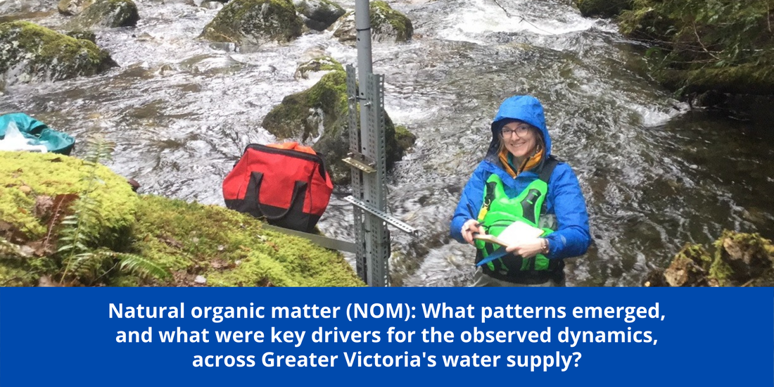
Picture
Research Overview
​​
​This research established a stream water sampling program across a second-growth forested drinking water supply area (Vancouver Island, British Columbia, Canada) to contribute to our understanding of variability in natural organic matter (NOM), a master water quality variable important for source drinking water treatability. Over sixteen months (October 2018 to February 2020), 426 stream water samples were collected from 12 sites (ranging from 9.6 to 37 km2, elevation 215 to 870 m a.s.l) from across the Greater Victoria water supply area. Samples were analyzed for NOM quality (via UV-Vis absorbance) and quantity (as dissolved organic carbon, DOC). Results were used to evaluate spatial and temporal patterns and to identify key drivers for NOM dynamics. Important for contaminant transport, NOM quantity was correlated with several metals (e.g. total mercury, aluminum, iron), and its molecular character was correlated to carbonaceous chlorinated disinfection by-products.

Six sites in Leech River watershed (~96 km2) were equipped with vertical passive sampling racks to evaluate hydrograph rising limb NOM dynamics. Approximately 80% of the time, DOC concentration peaked with stream stage. Hydrologic connectivity to terrestrial source pools increased throughout wet seasons and antecedent wetness was important for stream NOM molecular quality, which shifted from predominantly aliphatic in the dry-season to predominantly aromatic in the wet-season. This suggests that in-stream, biological processes dominated NOM quality during the dry-season (summer), whereas wet-season (fall and winter) NOM was more linked to the landscape and driven by hydrology. Random Forest variable importance measure (RF VIM) identified warm and wet conditions as key drivers for NOM dynamics. RF VIM showed that forest age and harvest history were somewhat important predictor variables for NOM aromaticity and molecular size, but that subsurface parent material (e.g. metamorphic rather than igneous) was relatively more important as a predictor of NOM quantity and quality.
Picture
Bio: Hannah J. McSorley

​Hannah is an environmental science professional specializing in watershed science and freshwater quality. Her Master's research was focused on the spatial and temporal variability of water quality and hydrologic response across a regional drinking water supply area (Capital Regional District, Victoria, BC). Prior to starting grad school, Hannah was a Research Assistant with Bill Floyd's Coastal Hydrology Research Lab, based at Vancouver Island University (VIU). Hannah also worked for the Regional District of Nanaimo's (RDN) Drinking Water & Watershed Protection Program as a Special Projects Assistant. She continued to work with the RDN as a contractor through the first term of grad school, analyzing water use and production data and evaluating water conservation programs. 

​Hannah's research experience started in the Applied Environmental Research Labs, where she worked her way up from general tasks (like acid washing glassware and taking inventory) to a position of senior research assistant. When she graduated with a BSc, Hannah was the primary chemical analyst on an industry-partnered groundwater project which showcased her ability with operation, maintenance, and repair of analytical instrumentation (Membrane Introduction Mass Spectrometry). 

Currently, she is working a temporary assignment with the BC Ministry of Environment in the Snow Survey Program and learning all kinds of new things. Hannah loved working with community water services and is thrilled to conduct scientific research in the field and the lab. She continues to develop skills in data handling and data analysis, project management, field techniques, technical writing and communication. Her Snow Program contract runs to July 2021 and, although the details are yet to be determined, she's looking forward to continuing her research career after that.

0 Comments

    forWater Network

    The Network provides insights into new scientific research for safe, secure drinking water---globally---which starts with resilient forests

    Archives

    January 2021
    December 2020
    November 2020
    October 2020
    September 2020
    July 2020
    June 2020
    September 2019
    August 2019
    May 2019
    February 2019
    August 2018
    March 2018
    February 2017
    June 2016

    Categories

    All

    RSS Feed

Picture
Picture