
|
Hokanson KJ, Mendoza CA, Devito KJ. 2019. Interactions between regional climate, surficial geology, and topography: Characterizing shallow groundwater systems in subhumid, low-relief landscapes. Water Resources Research, 55(1): 284-297. DOI: 10.1029/2018WR023934.
Summary In this research we provide the first comprehensive characterization and synthesis of groundwater movement and water table behaviour in the Boreal Plains region of Canada. Topography is often used as a first order control over groundwater movement, however we show that in the low-relief, sub-humid Boreal Plains, topography is not a good predictor of water table position, and therefore groundwater flow patterns. We offer a discretization approach (i.e., categorizing or classifying) as an alternative to the traditional surface topography based approach of establishing watershed boundaries. Instead, we use hydrogeological response areas (HRAs), which are defined by substrate characteristics. 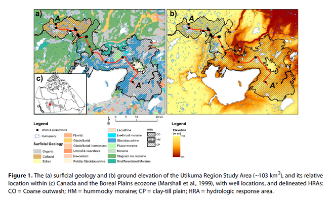 Results Our findings show that the use of HRAs to evaluate hydrogeological characteristics of typical glacial landforms provides a convenient and holistic way of discretizing the landscape into unique sub-units defined by hydrogeological properties and water table conditions. By examining the magnitude and frequency of water table fluctuation, vertical hydraulic gradients, geochemical signatures, and stable water isotope ratios over 19 years, we demonstrate that groundwater is controlled by a hierarchy of climate, geology, and topography. Application HRAs are used to delineate chemoscapes and isoscapes (spatial distributions of geochemical and isotopic compositions of groundwater and surfacewater) to provide practical pre-disturbance hydrogeological benchmarks for developing land management practices. The results of this study provide managers and stakeholders with an understanding of the dominant controls on hydrological processes and indicates the value of focusing at an intermediate scale between the basin and the hillslope scale. We demonstrate that managers should consider the complex interactions of topography, recharge, and texture when planning and managing disturbed lanscapes because they are more spatially and temporally variable than previously thought. Key Messages
0 Comments
Leave a Reply. |
forWater NetworkThe Network provides insights into new scientific research for safe, secure drinking water---globally---which starts with resilient forests Archives
October 2023
Categories |


 RSS Feed