|
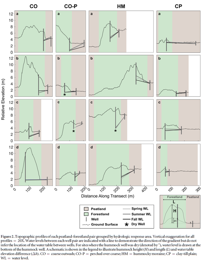
Hokanson KJ, Peterson ES, Devito KJ, Mendoza CA. 2020. Forestland-peatland hydrologic connectivity in water-limited environments: Hydraulic gradients often oppose topography. Environmental Research Letters, 15:034021. DOI: 10.1088/1748-9326/ab699a. Summary This study identifies the hydrologic sink (i.e., where a land unit produces more water than it stores or consumes) or source (i.e., where a land unit stores or consumes more water than it produces) function of forested uplands and peatlands in the Boreal Plains region of Canada. In humid environments, it is common to think of the water table as we do surface topography, where water flows from topographic highs (e.g., hills) to topographic lows (e.g., valleys or depressions). This concept is also widely applied to peatland hydrology, where the assumption of peatlands being ‘fed’ water by adjacent forestlands through topography-driven flow is prevalent. This may not be a realistic representation of hydrology for low-relief and sub-humid regions, as shown by this study. Methodology Sixteen forestland-peatland pairs were selected and monitored in a variety of topographic and geologic settings to test this assumption. Results We show that during a mesic (non-drought) year most peatlands are, in fact, potential sources of groundwater to adjacent forestlands. We also found that forested hummocks are not stable sources of recharge to the larger landscape in the sub-humid Boreal Plains. It is suggested that peatlands and sparsely vegetated sandy hillslopes are likely key sources of water, however due to the high water demand of aspen forests, fine-textured hillslopes are usually hydrologic sinks. Because peatlands are a major source of DOC and nutrients to the larger landscape, understanding their hydrological role is key in predicting both water quality and quantity. Key messages
In peatland and forest hydrology there is a silent but prevalent assumption that water flows from highs (forested uplands) to lows (wetlands/peatlands), even in sub-humid, low-relief areas. This paradigm presents itself in conceptual site models, assumptions for subsurface water flow between boreal forests and peatlands in numerical models, and in new approaches for peatland construction following large-scale disturbances. We present measured water table elevations from 16 forestland-peatland pairs in a concerted effort to demonstrate that this common assumption is more of an exception than a rule at the hillslope-scale in sub-humid regions, like the Boreal Plains region of Alberta, Canada. Aspen forests are actually poor sources of water to the larger landscape, and peatlands are the primary water source for runoff. Water treatment considerations This work underscores that the drinking water treatment community needs to increase its understanding of how water quality and hydrology are coupled, especially in complex environments like the sub-humid region of the Boreal Plains.
0 Comments
Leave a Reply. |
forWater NetworkThe Network provides insights into new scientific research for safe, secure drinking water---globally---which starts with resilient forests Archives
October 2023
Categories |


 RSS Feed

